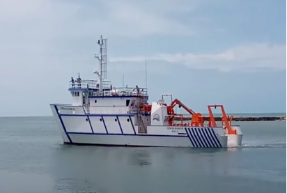
SWOT-Abrolhos: A Franco-Brazilian experience at sea As part of the SWOT-Brasil project, the LMI TAPIOCA launched a sea campaign in partnership with UFPE to validate the recently launched SWOT satellite. It is the first experience in the TAPIOCA project, where the Brazilian boat “Ciencia Do Mar IV” is used; so far, the Abraços 1 and 2 and AMAZOMIX campaigns have happened on the Anteá.
Context
The SWOT satellite (Surface Water and Ocean Topography), launched on December 16, 2022, is a pioneering technological step in measuring ocean topography with an altimeter, which provides access to ocean circulation, sea level variations, and thermal content. The new interferometric instrument allows unprecedented measurements in a broad band of 60 km on either side of the satellite’s passage, with unencumbered estimates of the sea surface at scales of 15 km.
It is a technological breakthrough compared to nadir altimeters, providing reasonable quality sea-level estimates for scales above 50 km.
From May to July 2023, the satellite follows a one-day orbit to revisit the ocean at high frequency (the rapid sampling phase). As a result, the University (UFPE), currently operating the research vessel “Ciência Do Mar IV”, can conduct a dedicated oceanographic survey in the area of interest and provide value in situ measurements to better understand circulation and marine ecosystems.
Prior Knowledge
The Brazil Current, a meridional branch of the subtropical gyre of the South Atlantic, follows and interacts with the continental shelf and carries warm, salty, and oligotrophic subtropical waters towards the pole. At 16°S, it is successively deflected by the Royal Charlotte and Abrolhos banks, generating semipermanent systems of cyclonic and anticyclonic eddies, also interacting with the intermediate flows towards the equator under the thermocline. This mesoscale activity progresses towards nutrient-rich surface waters that stimulate primary productivity.
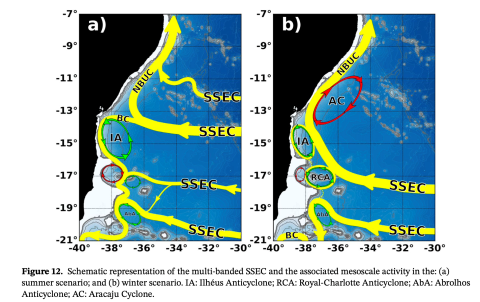
© Figure tirée de Luko, C.D., I.C.A. da Silveira, I.T. Simoes-Sousa, J.M. Araujo, et A. Tandon,
The invasion of the Brazil Current has caused the intrusion of central South Atlantic waters into the Abrolhos banks. These banks, extending the continental shelf over 220 km, constitute the most prominent and prosperous complex of modern tropical reefs in the southwestern Atlantic. “Abre os Olhos” (Open Your Eyes), sailors used to say to warn of the risk of shipwrecking on these coral reefs. The northern flank is very shallow (10-30 m) and comprises an archipelago of five islands, the largest of which is 1 km long and 35 m high. The rich diversity of reefs has shaped the topography over the years. Due to the rich endemic biodiversity and unique species of coral reefs, Brazil established its first marine protected area in 1983 to limit the impact of local fishing and tourism.
The Abrolhos banks are located in the southern trade winds regime and on the northern flank of the South Atlantic anticyclone. The zone is, therefore, subject to an east-northeast regime for most of the year, which changes to an east-southeast influence in late autumn and winter. A constant swell regime comes from the centre of the South Atlantic, with a typical wave height of 1 to 1.5 m that affects the banks for most of the year. In addition, semi-diurnal tides, with a maximum range of 2.5 m, propagate from south to north of the banks. The associated tidal currents can reach 50 cm/s in some channels and alter the overall pattern of the Brazil Current southward on the banks.
Lack of Knowledge
The Abrolhos Bank and the Vitoria-Trindade Chain impose solid topographic constraints on the mean flow and generate mesoscale turbulence. In addition, internal tides appeared in the south of the chain. However, it is possible to observe the circulation at a finer scale, in geostrophic or non-geostrophic balance, which is described poorly in these areas, where the influence of wind and waves from the South Atlantic, tidal currents, and the interaction of all these factors with large-and mesoscale flows.
Research Objectives
The SWOT-Abrolhos campaign aims to characterize the circulation at a fine scale in the Abrolhos Banks during mid-autumn and provide observations on currents and waves compared with SWOT measurements and regional model simulations. It will also assess how the current nadir altimetry constellation describes the circulation.

The Brazilian research vessel “Ciência do Mar IV will conduct a synoptic survey. The deployment of two shallow moorings measuring currents and waves took three months. The SWOT-Abrolhos campaign will provide new fine-scale circulation observations for this highly biodiverse area. In addition, it will assess how SWOT captures samples of this circulation and enable dedicated modelling studies to characterize interactions at all scales in this critical topographic region for the circulation of the South Atlantic.
A second cruise will happen with the “Ciência do Mar IV” to recover the two moorings and conduct a new ADCP survey with the vessel at the end of July 2023.
Within the scope of IMT TAPIOCA, this marine campaign represents a new opportunity to foster collaboration between Brazilian and French research and contribute to validating the international SWOT mission. It also entails a comprehensive sharing of resources to facilitate scientific work.
Principal researchers: Fabrice Hernandez (IRD/LEGOS, fabrice.hernandez@ird.fr), Alex Costa (UFPE/DOCEAN, alex.csilva@ufpe.br), Marcus Silva (UFPE/DOCEAN, marcus.asilva@ufpe.br).
Associated researchers: Ariane Koch-Larrouy (IRD/LEGOS), Ramila Viera (UFPE/DOCEAN), Moacyr Araujo (UFPE/DOCEAN), Leo Bruto (UFPE/DOCEAN), Pedro Melo (UFPE/DOCEAN), Vincent Ventrepotte (CNRS/LOV).
Institutes involved in the campaign: Institut de Recherche pour le Développement (IRD), Centre National de Recherche Scientifique (CNRS), Laboratoire Mixte International TAPIOCA, Universidade Federal de Pernambuco (UFPE).
Contact point for the study’s website: Fabrice Hernandez (fabrice.hernandez@ird.fr).


