

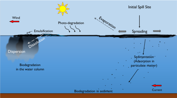
In this work we coupled the Ocean Modelling System – ROMS Regional Oceanic Circulation model with the MEDSLIK-II hydrocarbon dispersion model to simulate the evolution of accidental oil spills from tankers that travel near the Fernando de Noronha Archipelago in the tropical Southwest Atlantic. Six scenarios were evaluated, consisting of three spill positions on the eastern side of the Archipelago and two months (March and July). The results show that the predominance of advective forcings would tend to counteract the oil degradation processes and shorten the time window for possible mitigation actions. The worst scenario occurred in March with the plume reaching the island within 48 hours with 2.3% of the initial volume (1350 tonnes) adhering to the shore. The affected region is part of the Fernando de Noronha Marine National Park area. We propose the delimitation of a region between 3°41.9’S and 03°57’S and ~62 km perpendicular from the eastern limit of the FNA, restrictive to tanker traffic to increase the time window response in case of an oil spill.
Keywords
Semi-lagrangian model, ROMS, MEDSLIK-II, Fernando de Noronha Archipelago, Oil wheathering.
Reference
Syumara QUEIROZ¹*; Laila FAZEKAS¹; Marcus A. SILVA¹; Moacyr ARAUJO¹
¹ Laboratório de Oceanografia Física Estuarina e Costeira, Departamento de Oceanografia da Universidade Federal de Pernambuco – LOFEC/DOCEAN/UFPE, Av. Arquitetura s/n, 50740-550, Cidade Universitária, Recife, PE, Brazil.