

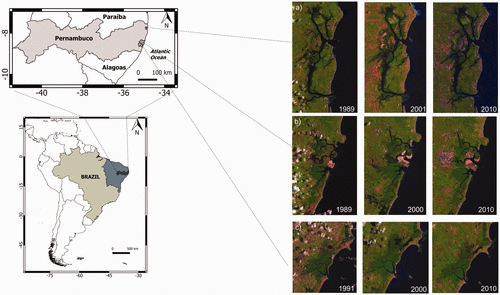
It is essential to monitor both the mangrove coverage and the encroachment of anthropogenic activities to assess the evolution of these highly valuable and threatened ecosystems. Using the grid technique, Landsat images of three estuaries in Pernambuco, northeast Brazil, were analyzed to track changes in land use over the past three decades. This study is the first time the grid technique has been used as a precise method to quantify and localize the mangrove coverage changes at local scale. We found that the technique was a synthetical and cost-effective way of observing land-use changes over the study period, and its precision was evident for local-scale study. An increasing trend of mangrove coverage was observed and can be related to the salinization. This increase in salinization is a result of anthropogenic activities and climate change. We also found that differences in geometrical properties influenced the spatiotemporal patterns of mangroves. To mitigate adequately the negative impacts induced by anthropization and climate change, the characteristics of mangrove forest configuration and human activities should therefore both be considered.
https://doi.org/10.1177/1940082918822411
Reference
Pelage, L., Domalain, G., Lira, A. S., Travassos, P., & Frédou, T. (2019). Coastal Land Use in Northeast Brazil: Mangrove Coverage Evolution Over Three Decades. Tropical Conservation Science, 12, 1940082918822411.